 |
| The Spit Syphon "house" seen from Clotarf. The waters of Middle Harbour stretch between. |
| Most Sunday mornings, my girls and I go to the beach, not an ocean beach, but to two beaches within Sydney Harbour, Clontarf Reserve or Chinamans Beach. An eagle-eyed reader spotted a structure that he recalled from his 1950s childhood in the area. So, here for you, Fig Mince, some details. |
 |  |
| Two historic images from Sydney Water. Left: Pipe ready for launching, 1929; Right: Titan crane ready for the construction |
| From 1916 to about 1933, the Metropolitan Water, Sewerage, and Drainage Board (MWS&DB), now known as Sydney Water, rationalised the sewerage infrastructure across the northern half of Sydney, a massive area, and a massive undertaking. Known as the Northern Sydney Ocean Outfall System (NSOOS), the infrastructure stretched from Flushcombe Road in Blacktown, through Parramatta, Ryde, North Sydney, Mosman, Clontarf, and Harbord, ending up being piuped into the Pacific Ocean off Blue Fish Point Reserve, Manly. Yes, folks ... raw sewage straight from the home to the ocean. It only took them 60 years to put a treatment plant as the last stage of the system. Mind you, it took most of those 60 years for the citizens to demand that environmental change. |
 |
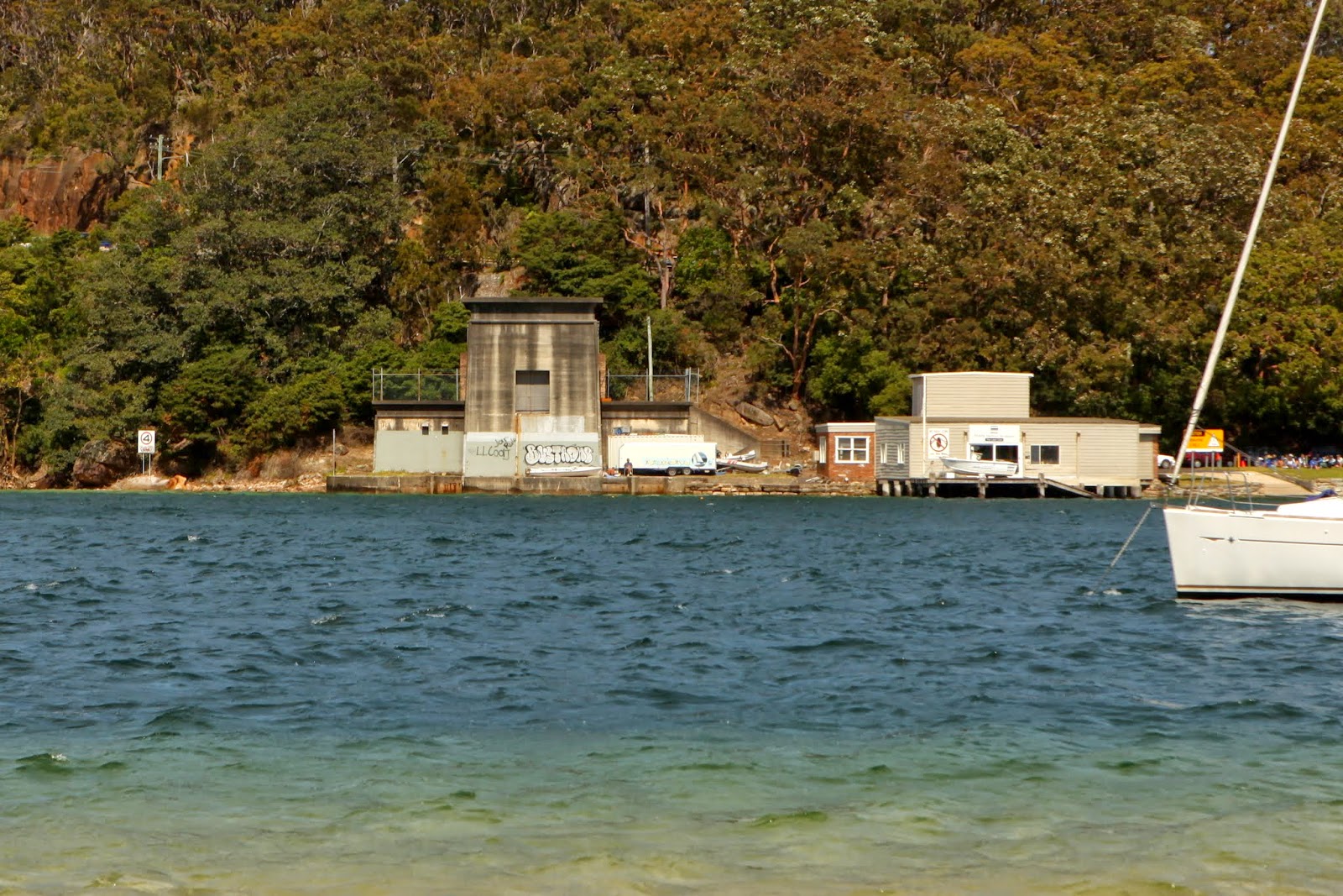
| Standing on the steps of the Clontarf "house" looking toward the Spit. Chinamans Beach is to the left of the photo, on the far shore. |
| Between Chinamans Beach and Clontarf Reserve is the entrance to Middle Harbour, regularly used by pleasure craft. Pleasure craft owned by lots of wealthy folk. The sewerage pipes were placed on the bottom of the entrance to Middle Harbour. At either end of this section were constructed two Egyptian inspired structures to cover and disguise the system. |
 |  |
| Left: Digging into the hillside to meet the pipe coming from North Sydney; Right: the housing not long after construction. |
| This section was powered by a "syphon". Hence, the structure that Fig Mince recalled came to be known as "the Spit Syphon". A spit is a marine landform, meaning deposition of sand. A syphon is a means of moving liquid uphill without a pump. There is a syphon in the Lane Cove section of the NSOOS, which had "branch lines" added to it as the northern half of Sydney expanded. Lane Cove, Castle Cove, and Hornsby were three such additions. More about the Spit Syphon tomorrow. |
 |
| The housing at the Clontard end of the syphon today. It would have to be one of the more ugly strucures on the harbour. But then, all utility structures are ugly. |
 |
| This is a map that doesn't do well when embiggened! There are two horizontal lines running across a map of Suydney. The top line is the NSOOS, the bottom line is the SSOOS ... guess that acronymn ... |
4 comments:
I see it's not been kept safe from taggers.
Interesting. Out at Clandulla we don't have sewerage yet. And don't want to invest in septic because the sewer is coming sometime never. So we have to use a chemical toilet and go empty it regularly. A yuk job. Can you imagine swimming it!
Hi Julie, thanks for this. It’s weird to finally find out what it was all about sixty years later. I’m in awe of your researching skills.
Interesting read about the spit syphon.
Post a Comment