Monday, 22 February 2021

Steam Trams and The Bridge Street Yard

The Bridge Street Yard from a nearby building (looking north). Taken c. 1899 and sourced from the "Trams Downunder" website.

Marty McFly knew all about going backwards to make any progress. Sydney goes backwards. Sydney goes around in circles. And sometimes just this propulsive need, pushes the city forward. At the moment, we are constructing a tramway system through the retail and financial heart of the city. But, hang on a tick, some of you may cry. Didn't Sydney have an extensive tramways system... shhh ... shh ... backwards, remember. One must go backwards to get to the future.

The first tramway in Sydney lasted from 1861 until 1866. It closed down because other "road" users were inconvenienced by the rails .. and the competition. Just like in the mid-1950s, the NRMA set up a hue'n'cry about the trams, and how they inconvenienced citizens devoted to the family car, and the supremacy of the individual vs the collective. So that second go at a tramway in Sydney lasted from 1879 until 1961. Steam trams pulled the carriages from 1879 until about 1905, when electricity took over. Coal fired, got it?

Top - This photo is off-putting as it distorts the intersection. The telegraph polein Bridge St and it goes up'n'over and continues on to the top right. Meanwhile, Phillip St comes in from cenrtre left and goes out the bottom right (before 1902, sourced from SR-NSW)
Bottom Left - This is a Henry King photo held by the PHM and dated 1890. It shows one steam tram going into the yard, and another coming around the corner of the Colonial Secretary's building ready to cut diagonally across the intersection and follow suit.
Bottom right - This image is undated, and is sourced from John Cowper's Flickr A/C. We are looking straight up Phillip St (south) and the steam tram is disappearing into the yard on our left.

Steam trams came into the city on their various routes, and had to wait somewhere before the return jpourney. Their crew needed facilities. This yard was their waiting shed.

Now Sydney is a very beautiful city, situated as it is on a harbour. But that harbour occupies a drowned valley, a very deep drowned valley. Sydney has been built on all the ridges and valleys that remeined. It is very tortuous. Beautiful, but rugged. Not all lines could adapt to the steam-tram as they were too steep. The Edgecliff to Erskineville Street Wharf tram had to be pulled by cable to get it up and over William Street.


Saturday, 2 July 2016

Theme Day - Looking Down

Taken from the top of the southern pylon of the Sydney Harbour Bridge. Looking due east, down the harbour, out to the Pacific Ocean.


This post is my contribution to the City Daily Photo Monthly Theme Day. To see the contribution of other members of CDP please visit the portal.

Tuesday, 31 May 2016

Theme Day - Shadow & Highlight


Last weekend, I tramped around beneath the southern approaches to the Harbour Bridge, in an attempt to reproduce the attached 1927 image. I think the photographer had been on the first floor balcony of a terrace behind me to get his elevation. Where I captured the Opera House on Bennelong Point, he captured the Tram Sheds! The icing on the cake for me was the troupe of "Bridge Climbers".

Southern Pillars (1927)(State Records, New South Wales)

This post is my contribution to the City Daily Photo Monthly Theme Day. To see the contribution of other members of CDP please visit the portal.

Thursday, 19 May 2016

Mostly Man O'Peace

Above: Image by Charles Bayliss (1881)(sourced from Blue Mountains Local Studies Centre)
Below: Image by Julie Storry (May 2016)


We refer to this pier, and these steps as "Man O'War Steps". Although originally constructed during the governorship of Lachlan Macquarie (1810-1821), he only named the little enclosed beach as Port Lachlan, after his son. The current name stuck from about the 1860s. Even so, the name has lasted longer than the original jetty.

Above: Man O'War Steps, with HMS Royalist in foreground (from The Phillips Collectiuon housed at the Power House Museum)(c. 1900)
Below: Image by Julie Sytorry (May 2016)


As you can see, from just three historical images, both the shape and the accessories, morph over time. Pontoons have been added, and removed. Sheds have been constructed; sheds have been demolished. Gates have been installed; gates have been moved.

Above: HMAS Australia I at Man O'War Steps (Image by Harold Cazneaux) (c. 1919)(NLA)
Below: Image by Julie Storry (May 2016)


Taking my share of these images, I had my back to the Sydney Opera House. When it was constructed - during the 1960s and early 1970s- the Man O'War area was devastated, save for the steps. The safe-harbour for the watermen and their pointy-skiffs, never returned. Neither did the (naval) waiting sheds, regardless of whether the waiting was done by sailors wives, or by prostitutes.

Saturday, 30 April 2016

Theme Day - Smell


The past has a musty, stuffy smell of windows not opened enough, of sunlight not streaming enough, and fresh air not wafting enough.


The main entrance, on Bridge Street, of The Industrial Relations Commission of NSW, in part of the Chief Secretary's Building, constructed between 1873 and 1893..


This post is my contribution to the City Daily Photo Monthly Theme Day. To see the contribution of other members of CDP please visit the portal.

Monday, 25 April 2016

ANZAC Day 2016


All these images were made in Bathurst early in April, during a family visit.


"Kings Parade" is the central civic area of the city. It is rare to experience such a well-laid out, and well-preserved, central area to a country city. It is very moving.


These memorials occupy the centre-piece of the area, actually down through the centre.


Facing east, the left of the war memorials contains the court-house and the old civic buildings. The right of the memorials contains the Anglican cathedral. More on these two areas in future posts.

Lest we forget

Friday, 4 March 2016

The short-sighted photographer


Sydney Harbour is immensely busy, and the variety of marine craft just astounding. The photographic eye must continually move, like a toothbrush, left/right, top/bottom, infront/behind.


I wached the water taxi speed out from the Quay into the morning sunshine, and disappear. I looked up, and realised that I could see the other side of Sydney Cove, unlike the previous week when my view was blocked by a thumping big gin-palace!


Thursday, 3 March 2016

A "Sydney Living Museum" Pass


I have a Sydney Living Museum 3-month pass, that enables me to see four named museums for an investment of $8.

I saw the Museum of Sydney first, which is on Bridge Stree, down near Circular Quay, on the site of the first Government House. Then I went through the Justice & Police Museum, which is on Phillip Street, also down near Circular Quay. My third museum is this one: Hyde Park Barracks.


Hyde Park Barracks is on Macquarie Street adjacent to Hyde Park. It was commissioned by Governor Lachlan Macquarie, and designed and overseen by Francis Greenway. In 1817 it was ready for its first intake of convicts. From 1788 until then, convicts were mostly able to spend the night wherever they could find a roof. Where else were they going to run off too? Sydney was down the nether-end of the world! Those who did try to escape, died quickly in the unforgiving bush.


Wednesday, 2 March 2016

Beneath the Street


More and more of Sydney is beneath the streets. There are road tunnels, there are shopping malls, and there are railway stations.

This is one of the tunnels between St James Railway Station and street level. St James is beneath Hyde Park (North).


This tunnel leads towards Macquarie street, to St James Anglican Church, and to Hyde Park Barracks. It is a mass of city workers during the week, the Supeme Court of NSW being very close. But, I was there one Sunday morning.


Photo 1: A St James tunnel showing photos of its 1926 construction on the tiled walls.
Photo 2: The steps leading from the tunnel to the plaza outside St James Church
Photo 3: St James Church
Photo 4: St James taken from the forecourt of Hyde Park Barracks


Tuesday, 1 March 2016

Theme Day - Where do you Belong?


Where do I belong? Right here, in Sydney Cove, the birthplace of my country as a member of the international community of nations.

Though there had been indigenous peoples here for millenia, working the land, living, sharing, restoring the land; that was truly THEIR land. Their land is different from my land, although both lands are identical. A conundrum we need to work harder to explain to each other.

This central part of my city, nestled around this cove, gives me peace, and immense solitude, even amongst all the hustle and bustle. It is where I feel at home.


Today is Theme Day for the City Daily Photo group of bloggers. See where other photo-bloggers feel at home.


Sunday, 1 November 2015

The Barracks Veggie Patch - Part 1

Hyde Park Barracks (2013) with its red-pebble courtyard. The building immediately to its right did not exist in 1819, neither did the roads, obviously. The building on the extreme, upper right is the post-1865 St Mary's Cathedral replacing the original which burnt down. Its axis was east-west, rather than the current north-south axis. The veggie patch was to the right of the cathedral.

Left: Click on this to enlarge. It is an aerial shot taken from Sydney Tower. I have circled the area that was the original veggie patch.
Right: Taken from the southern steps of the rebuilt cathedral, looking across to the Museum. College Street runs down the right of the photo. It is a very sloping area, which added to the difficulties that the colonists did not forsee.

For the first quarter-century of the life of Sydney Town, the majority of convicts were not locked up. There was nowhere to lock them into, and just where were they going to run-a-way to? But then in 1810, along comes Lachlan Macquarie (the 5th Governor), who loved design and order. He did things like straightening streets, and constructing what are now called “public” buildings. One such was the Hyde Park Barracks: to lock the convicts up into when they weren’t out slaving in road-gangs. Once locked up, they had to be fed; the cheapest way possible was the mantra. The Governor allocated 11 acres, close-by, for a veggie patch.

Left: "Sydney from Woolloomooloo" (1837)(Robert Russell)(National Library of Australia). On the left is Sydney Grammar School, then the spire of St James, then the gardener's lodge, and in the distance right is the first St Mary's. Hyde Park Barracks is the orange-walled building poking out behind the cathedral.
Right: "View of Sydney from Woolloomooloo, looking West"(1839)(Frederick Garling)(State Library of NSW). Ignore the little building in the left foreground. In the middle-distance, we have another view of the first incarnation of Sydney Grammar, then the gardener's lodge. Still too early for the Museum. However. running down beside the lodge, and heading toward us is William Street, and the stone-bridge over the Yurong Stream. Way over in the background, on the right, stands the spire of St James, and to its right, St Mary's. There are walking paths criss-crossing the relatively steep field.

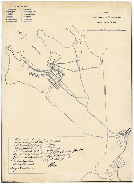
The first governor, Arthur Phillip, had determined a town boundary in 1792, just prior to his return to England. The barracks were close to the eastern edge of this boundary, an edge that was being rapidly populated with imposing government buildings, and parklands dedicated to both military use, AND the hoi-polloi. The veggie garden was constructed in 1819, after the area was denuded of its “forest” of Angophora costata (a native gum tree) and Eucalyptus pilular (a Blackbutt). It was the eastern limit of the Turpentine-lronbark forests supported by the underlying Ashfield Shale soils. The colonists were deluded into thinking that if the land supported all this natural vegetation, it would grow turnips, and carrots, and parsnips, and pumpkins, as well as potatoes and onions: all the ingredients for soup. By 1831, the experiment had failed, and the land left vacant.

Left: "A Survey of the Settlement" (1792)(Governor Arthur Phillip)(???). This is Phillip's "boundary line" inside which all the land was government land, and NOT to be given in grants to settlers. Typically Australian, future governors and civil servants overlooked this dictat.
Righr: "Plan of the Town and Suburbs of Sydney" (1822)(State Library of NSW). The site of the convict garden is laid out in a grid just off-centre, and numbered "40". To the right is heading east.

We now know this area as Cook+Phillip Park, between St Mary’s Cathedral (foundation stone laid 1821) and the Australian Museum (building work started in 1846) which is bounded primarily by College Street (street constructed in 1832) and William Street (construction commenced in 1836). The veggie garden pre-dates all four of these locators, occupying some of the Sydney Grammar land, most of the Museum land, the start of William Street, and much of the cathedral forecourt. However, it now exists in historic documents only. There is nothing on the ground as evidence that it existed at all.

Left: Photograph of the Gardener's Lodge (1880)(Australian Museum Archives). This is the only knpown photograph. There are artistic interpretations, as I have indicated. The lodge is the octagonal building on the right.
Right: Click on this 2013 photo of the Museum, in an aerial shot from Sydney Tower, I have included a big red X about where the lodge was located. In the 2015 rejuvenation of the Museum entrance, this spot has been overwhelmed by the "floating glass Crystal Hall" which I personally find under-whelming.

There had been physical evidence – once upon a time. The gardens were laid out as one would expect from those accustomed to English gardens: a large square divided by walkways into four (smaller) squares, with a central circle, and in this central circle, stood the gardener’s lodge. The octagonal lodge was located at the NE corner of the first Museum building which was opened in 1857. The lodge was constructed c. 1820 when hopes for the success of the venture were high. It was demolished between 1880 and 1885, in preparation for major remodelling of the two existing Museum buildings, and the construction of the third (southern) wing. It had been occupied by a police constable and his family in the 1840s, and then used by the Museum as a taxidermist’s workshop until c. 1865, when it was converted into a kitchen and wash-house. It was single storey, with a central chimney, made from brick and stucco, with a shingle roof.

Left: Frontispiece to "A History of NSW: From its Settlement to the close of the Year 1844" (1844)(Braim, TH)(Caroline Simpson Library & Research Collection, SLM/HHT). This appears to be a view from College Street, looking north-east over Woolloomooloo Bay. the Potts Point ridge, with Garden Island and Port Jackson.
Right: "Panoramic View of College Street and Hyde Park" (1867-1870) (Johan Nepomuk Degotardi)(State Library - NSW). The western swathe of the Convict Garden is, at least, fenced it, and appears to be hosting a couple of goats.

The convict garden was no more, but the "parkland" remained in government hands, being hived off for a range of uses until 1998. Sydney Grammar was allocated the southern-most portion beside the Francis Forbes allotment. Beside that, land was ear-marked for the Australian Museum, and behind that, one of a number of National Schools. A strip was used to widen the top-half of William Street, some temporarily given to the Blind Institute, some to the Hyde Park Nursery, and some allocated to a lawn-bowling club. Not only did the garden go to rack'n'ruin, but Hyde Park Barracks did not fare much better, until the 1970s, when a new civic awareness, and a respect for our convict heritage blew through the town.


"Looking south-east from the tower atop St James" (1871)(Supplement to Illustrated Sydney News)(State Library - NSW). The cathedral is a burnt shell. The northern side of the Museum is obscured by dense brush. The diagonal walking track through the convict garden is now a road for carts and gigs.

The Barracks Veggie Patch - Part 1
The Barracks Veggie Patch - Part 2 (coming soon)

References

"Lost Convict Lodge Rediscovered"

"The Convict Vegetable Garden that never really was"

Research Skills in Practice (2013) (Matthew Stephens, SLM)(Museum of Sydney)

The Sydney Gazette (8 May 1819)(P1-2)

Heritage Assessment: Cook and Phillip Parks (March 1997)(Lawrence Neild and Partners, Australia Pty Ltd)(Spackman & Moss Pty Ltd)(University of Sydney)

Etheridge, R., 1919. The Australian Museum—fragments of its early history. Records of the Australian Museum 12(12): 339–400, plates xlv–xlix. [4 December 1919]

The Domain: Volume 2 - Cultural Landscape Study (Royal Botanic Garden and Domain Trust)(Rosemary Annabel)

Cook+Phillip Park(City of Sydney)(March 2013)