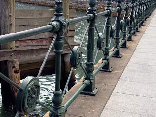
Sandringham Gardens are a memorial to King George IV of Great Britain. These steps lead to the sunken gardens from the intersection of College, William, and Park Streets. Diagonnally opposite The Australian Museum. Sydney Tower looms over Hyde Park, and the second shot also shows the MLC Centre on the corner of Martin Place and Castlereagh Street (in the background). |
Saturday, 28 February 2015
Hyde Park Sandringham Gardens
Friday, 27 February 2015
Pitt Street Mall - the retail heart of the City
This is the Pitt Street Mall in Sydney. It is built on the swamp from which the Tank Stream arose, that very stream which caught the attention of Captain Arthur Phillip in 1788. |
The original crowned street was pedestrianised in the late '70s, but it is this decade's renovation which has converted it into an outside living room. It has been estimated that 58,000 people wander this mall on any given weekend day. |
Here, by way of comparison, is the relevant section of Pitt Street in 1900, courtesy of The Powerhouse Museum. The cross street in the foreground is King Street. |
Thursday, 26 February 2015
Jaywalking
Wednesday, 25 February 2015
Hyde Park - A road runs through it
Taken in 2013 from Sydney Tower. A better view of Macquarie St is impeded by buildings. |
There was Macquarie Street. There was Macquarie Street North. And there was Macquarie Street South. Macquarie Street North still runs from the Opera House Forecourt to Bent St (the State Library corner). Macquarie Street runs from Bent St to Prince Albert Road/St James Road. Macquarie Street South no longer exists. The stretch from Liverpool Street down to Wentworth Ave was renamed Commonwealth St in 1905. It had appeared on the original subdivision of the Fosterville Estate in 1843 as Macquarie St. There was a Little Macquarie St parallel to Commonwealth St, but it was renamed Alberta St in 1896. I do not know when the road running north-south through Hyde Park was removed, but my guess would be around the turn of the century. |
Left: View of Macquarie St 1842, (John Rae)(State Library NSW) Right: View of Macquarie St, 1830-1850 (Ellis)(State Library NSW) |
I was amazed when I found the above two sketches of an early Hyde Park. I had no idea that Macquarie Street had bisected it. Park street bisected the park east-west in 1831. Park St, in the guise of William Street, ran up to Kings Cross from 1834. So, from 1831 to close to the end of the 19th century, Hyde Park was split into quadrants. No wonder Macquarie Street was truncated! |
Hyde Park (2007) commissioned from Airview by Dictionary of Sydney |
I am indebted to the City of Sydney, for their excellent "History of Sydney Streets" |
Tuesday, 24 February 2015
Hyde Park - Then & Now
Taken from Sydney Tower (Sept 2013) |
Hyde Park (Sydney), was set aside for public recreation by Governor Macquarie in 1810. Nowadays, it is split in two by Park Street. These two images show Hyde Park South. The State War Memorial was built in the early 1930s. Yesterday, I discussed the Lyons Terraces, which I have labelled on both images. The Australian Museum was commenced in 1844, but stood unroofed until 1850 due to a saandal about the mismanagement of public funds. So, immediatly there is something askance about the date of John Rae's sketch, which I sourced from the National Library of Australia. Sydney Grammar School commenced in 1830. The Lyons Terraces were constructed in 1841, diagonally opposite the already constructed Burdekin Terraces. Park Street is an extension of William St which continues up the ridge to Kings Cross. It was named in 1810 by Macquarie. Then it extended only to, but not through, Hyde Park. By 1831, it had crossed the Park to College St. And here is my second issue with Rae's sketch. He does not show Park St, yet shows the Australian Museum. William Street was gazetted in 1834 and named after William IV. I am not able to reconcile these inconsistencies. Tomorrow, yet another Rae sketch showing another road splicing through Hyde Park. There is a portfolio of Rae sketches at the NLA, most of them dated 1842. |
Sketched by John Rae (1842). He was prolific. |
Monday, 23 February 2015
Hdden agendas - Lyons Terraces
Left: George Edwards Peacock's 1849 painting showing Lyon's Terraces along south Hyde Park Right: A photograph of the same terraces just before their demolition c. 1910 |
Last week I took you on a nostalgic meander through "Brickfields Hill", part of Sydney that exists only through the swirls of time. The brick-fields existed from early 1788 and stopped - abruptly - in 1841. Yes, the reserves of the right type of clay could have been depleted after 53 years of hard scrabble. Yes, the township was burgeoning, stealthily creeping up the slope from Sydney Cove, and down into the swmp leading to Cockle Bay (now Chinatown and Darling Harbour). In the late 1830s, the barracks housing the military between George/Kent/Clarence Strrets (now Wynyard, after the last commandant), was moved out to the Paddington sand-hills because the inner-city land was too valuable. In July 1842 an act was promulgated by Governor Gipps, declaring the town to be a city. Transportation unofficially ceased in 1840 (officially for NSW in 1850). The colony was established, the inhabitants wanted their own say. Have you heard the expression "NIMBY" - "not in my back yard"? |
The closest I could come to reproducing the angle of thge original Peacock painting |
The early brick fields were one city block down from Hyde Park, which Governor Macquarie officially set aside not long after his arrival in 1810. It was a hodge-podge of wire-grass and rubble and even the hoi-poloi used it. However, in 1841 Samuel Lyons, a developer and auctioneer, built a series of terraces on the SE corner of Hyde Park. Three storey terraces. Terraces of such a quality, according to Joseph Fowles, `without exception the best in the city, (that) would not disgrace the Regent's Park in London'. Can you see where this is heading? Lyons was not the only developer with his eye on the main chance. Thomas Burdekin, an iron-mmonger and serial-real-estate-acquirer, built another row of terraces along College street diagonally across the way from the Lyons row. The smart set were not slow to acquire all these addresses. Doctors, dentists, lawyers, judges - the usual culprits - Dr Wallace and Chief-Justice Stephens, being but two. Any Sydney-sider of the 21st century will agree that the landform is prone to southerly-busters, not that they cause much damage, and after a swelteringly humid day, they bring blessed relief. However the brick fields were holes in the ground devoid of trees. The winds - known then as "brick-fielders" - would howl up the slope and across the barren Hyde Park, quite upsetting the learned gentry. So, of course, the brick makers were shafted and moved to all points west, like Pyrmont, and Newtown, and Camperdown. More on Hyde Park as the week progresses. |
Left: Hyde Park is no longer a race-track, nor a cricket pitch. This southern end houses the State War Memorial, and hence treated with more respect than the northern section of the park. Riht: These green plaques are all over the city. They give minimal info, but help to pin down a site. |
Sunday, 22 February 2015
Ooops - wrong time to be side-tracked
Friday, 20 February 2015
Bulletin Place
Bulletin Place runs between Pitt Street, and Macquarie Plce, just back from Circular Quay. This is where J. F. Archibald first published "The Bulletin" back in 1880, so one assumes this little alley was frequented by the likes of Henry Lawson, and Banjo Patterson. The land on which these 1880 warehouses stand, was part of a grant to Andrew Thompson on 1 January 1810. The survival of these three warehouses, all on shallow sites in a narrow street, retains a tiny part of an historic streetscape. Bulletin Place is situated on land reclaimed from the mouth of the Tank Stream, which runs in a stormwater drain beneath Pitt Street. |
Thursday, 19 February 2015
Semi-circular Quay
The curve of the quay wall between Wharf 1 and Wharf 2 on the eastern side of the quay. |
In the beginning ... the head of Sydney Cove was a tidal mudflat where the Tank Stream dribbled into the harbour. The cove, as Governor Philip noted in January 1788, was a deep harbour where ships of the realm could anchor in safety. Between 1837 and 1844 a military officer of the Royal Engineers, Captain George Barney, created a semi-circular quay, building a seawall and utilising thousands of convicts to reclaim about four and a half hectares of mudflats behind the wall; most of this fill came from the sandstone precipice dividing the two ends of Argyle Street, resulting in the Argyle Cut. The rest was cut from what is now the Tarpeian Walk adjacent to the Opera House forecourt. |
Left: A sketch by Jacob William Jones in 1845 (SL-NSW); Right: The balaustrade that sits atop the sandstone sea wall constructed by Barney and his iron-gangs. |
It was not until 1854, however, that the quay was completed with the closure of the space where the Tank Stream entered the cove. It was after this closure, that the populace started to warm to the name "Circular Quay", even though the space is more a semi-oval. The Tank Stream now enters Sydney Cove in a storm-water drain just as you round Wharf 6 for the stroll along the front of the Museum of Contemporary Art (MCA). |
Left: A bustling Circular Quay in 1870 (National Archives of Australia number A1200, L85037
TLF resource R2583) Right: Barney's wall beside Wharf 2 |
Wednesday, 18 February 2015
At the bottom of my garden ...
Of course, it is not possible for EVERYONE to have fairies at the bottom of their garden. Nor is it mandatory to push your luck as far as Frances and Elsie did in their Cottingley garden in 1917. But, the joy and delight in young faces, as I chat to them as Pixie Dimple is to treasure. Not to mention our little shadow in the corner, there. The child is portrayed by Juliet, a 16 month old grand-child. The cat is portrayed by Selsie, an eight yo female tabby. |
Tuesday, 17 February 2015
Brickfield Hill (2) - the brick fields
Hordern's Palace Emporium, fully constructed in 1924. The first store, built 1879, was burned down. There had been a Horderns of some ilk on this stretch since c. 1830. |
As I mentioned in my previous post, brick-making commenced in Sydney town in about the March of 1788, when Governor Philip set James Bloodworth loose on the then outskirts of town. The centre of their universe was Sydney Cove (what we now celebrate as Circular Quay), ahd some brave and hardy souls made it through the bush and rocky ridges up the slopes to what appeared the "top", which is now the Town Hall precinct. This is where the burial-ground came to be located, "boot-hill" if you will. I open with the iconic image of Anthony Hordens Department Store, the Palace Emporium, sited on George Street, between Liverpool and Goulburn Streets, backing onto Pitt Street. This massive city block was the guts of the brick making "industry" in the first 50 years of the penal colony. The block next to it (Pitt Strret to Castlereagh Strret between Liverpool and Campbell Streets) was also over-run by tag-a-long industries like pottery works See the references below. Pottery making had more requirements for water, hence the proximity to Cockle Creek. So, the brick fields ran up the slope, from Cockle Creek (now Belmore Park and Hay Street) to the top of the ridge which has Bathurst Street running along its spine. |
1807/1878 map of the burgeoning colony. |
I have used this 1807 map before, but it serves as a useful image to get the locale AND the topography firm in one's mind. Of course, this belt of industry could not last in this area. Not once the colony stood on its own two feet, and threw off the apron-strings of Mother-England. Bathurst Street was nowt but the first east-west ridge (there were numerous north-south ridges, channelling the rains and seeps down to the drowned river valley which was Sydney Cove). The two images below serve a useful counter-point. The colour one I took standing on George Strret looking north from Rawson Place (in line with Central Station). You can see the rise on the right, Where those large office blocks are is where the brick fields were. Where I am standing, is where the swampy beds of Cockle Creek occasionally flowed. Remember, I noted in yesterday's post that the top of the brick field hill was chopped off and spread hereabouts in 1838. The B&W image is of the same set of streets, but pointing south. The water-wagon is heading straight for the stone building on Hay Street which is/was a branch of the city library. The spire of Christ Church St Laurence at Railway Square is prominent in the back ground. All this traffic, horses and wagons, uncle tom cobbley and all, are traversing reclaimed land. Reclaimed by the blood, sweat, tears, and aching backs of road gangs, and brick carters. |
First image looking north up George St from Rawson Place (2015). Brick fields had been on the right, Second image, looking south down George St towards Hay Street (1900) |
Below is the slope of Pitt Street as it rises to the south. The pub on the corner of Pitt and Cambell, The Chamberlain, was built in 1902, on the spot where the most extensive of the pottery works was established, that of Skinner, Moreton, and Leak, and especially Thomas Ball. Brick-making stopped in this vicinity in 1841. But, why? Had the reserves of a specific quality of clay petered out? Or were there other agenda afoot? |
Looking north up Pitt St from Campbell St. The brick fields had been on the left and the pottery kilns on the right. |
REFERENCES Casey & Lowe, "Archealogical Investigation, 710-722 George Street", June 2011 Casey, Mary "Local Pottery and Dairying at the DMR site, Brickfields, Sydney, New South Wales", Australasian Historical Archaeology, 17, 1999 Thorpe, Wendy, "Albion Place: Historical Review", Cultural Resources Management, 1998 Maclehose, James "Picture of Sydney and Strangers Guide in NSW, 1839. Facsimile Edition. John Ferguson Pty Ltd, 1977 Marcom, Edward West (Ed.) Memoirs of Obed West: A Portrait of Early Sydney, Barcom Press, 1988 Turnbull, Lucy Sydney - Biography of a city, 1999, Random House |
Monday, 16 February 2015
Brickfield Hill (1) - The Hill
George St from Bathurst St, c, 1890 (SL-NSW) |
Brick-making commenced in Sydney within weeks of the arrival of the First Fleet. James Bloodworth, a brick-maker in England before being transported, stumbled upon a usuable clay, and once this proved hard to retrieve, he worked his way further up the slope, away from the creek, and lucked upon a goodly supply of better quality clay. Of course, this was some distance from the small colony on the harbour. The creek became Cockle Creek, the brick-field became enclosed by George Street, Liverpool Street, Castlereagh Street, and Campbell Street. All to the east of George Street. |
George St from Bathurst St last week |
This area was mined for its clay from 1788 until 1841. Brick-making then moved slightly further afield to places lke Newtowm, Camperdown, and Pyrmont. By 1841 the colony was expanding rapidly. The Old Burial Ground had already been closed in 1820 and a new one commenced in Devonshire Street on the other side of Cockle Creek. George Street was teaming with industry and bullock wagons hauling timber, and fleece. |
Sketched 1796 by Edward Dayes, purporting to be of the brick field hill on the way to Parramatta (NLA) |
The original boundary of the colony was deemed to be the current location of Bathurst Street. But there was an issue with the intersection of George Street - the main artery from the harbour - and Bathurst Street. After, a long, steady incline up from Cockle Creek, there was a sudden increase in gradient, before steadying to travel past the ex-burial ground. This was the brick field hill. The bullock teams and sulkies struggled. In 1838 a major piece of public works saw the brick field hill up George St, reduced 15 feet in height between Bathurst and Liverpool Streets, and made more gradual in gradient, with the millions of tons of spoil (mostly sandstone) being used to reclaim the southern end of Cockle Bay and to elevate the southern part of George Street. Convict labour was plentiful, what with teams of men hauling bricks from the brick fields to the government buildings around the cove, from dawn to dusk already. These teams came either from the Carters' Barracks - on one edge of the Devonshire Burial Ground, now Central Station - or, from the hulk "Phoenix" anchored out in Sydney Cove. They simply chopped the top off the hill. Yep, that sort of behaviour is still in our genes. |
Looking across George St, and down Bathurst St to the west (2015). About 15 feet of rock has been removed. |
Sunday, 15 February 2015
CNY '15 - The Year of the Sheep
Saturday, 14 February 2015
The New Black - Flowers & Cafe Chairs
This post is a bit of an in-joke. Of course, it shows neither flowers, nor cafe chairs. However, they are, in my pea-brain, just word symbols for an easy-shot. Yes, yes, I know. No shot is easy. But I particularly like shots where I have to dig and delve. With most shots, I can manage the width, and the breadth. It is when I get to the depth, that I find the real challenge in photography. Depth, of course, is time. |
No third dimension here. I can knock the post out in twenty minutes. This is my front garden, where I spend most of my time. Today, I trimmed the hedge - by hand. I transplanted out more pots with St Valery Carrots. Put in more Coriander seed. Added two more Globe Beetroot seeds. Pulled out yet another cucumber plant, leaving just the one now. Figured I really only had space for one, not two, Rockmelons. And prepared the soil for the seeds which arrive from Diggers on Monday, namely: Broccoli, Cauliflower, Parsnip, Spring Onions, and Pumpkins. Next, from my potting bench down the back garden, I have to find some pots to scatter between the veggies, to grow some Red Marietta Marigolds. |
Friday, 13 February 2015
Then & Now - West Circular Quay
This B&W image was made by Harold Cazneaux during 1931, as the construction of the Sydney Harbour Bridge was in its final stages. The first of my colour images was made from the Cahill Walk, with the second being made from the railway station concourse (which is the level beloow the Cahill Walk). |
In my book on the photography of Cazneaux (1878-1953), the historian, Philip Geeves, contends that the Cazneaux view of West Circular Quay appears to be "strangely uncluttered". In my colour images, the cluttering is mainly done by the bloody cruise ship. Ban the, Ban them all, I say. Opening up the length of the quay to pedestrians declutters, I feel. That street running along the quay towards the bridge, which is an extension of Pitt Street, has been closed off allowing pedestrian access down to the balaustrade of the Quay itself. |
I promised more details on Brickfields Hill. They are coming, hopefully next week. There is so much reading to do, to verify facts, and then I realise I do not have just the right image to illustrate the point. Perhaps, I should instead cover flowers, and cafe chairs ... |
Monday, 9 February 2015
l'histoire de faux
Fake ageing - like fake French - confounds me. I can understand why the perpetrators descend to this. The are scrabbling around for an ambience on which to hang their narrative. This is Albion Place in the CBD, which runs from George Street through to Kent Street, between Bathurst and Liverpool Streets. It has been an access-way since 1834. Melburnians call them "laneways", and create wonders, which are abuzz with bustling citizens. Real folk: meeting, chiacking, guffawing, spending. Here in Sydney we create a dead-zone, of use to some of the people, some of the time. So, what is faux here? Specifically, the three wall signs which are all for Black Country businesses back in the United Kingdom. The Walsall FC team are known as "The Saddlers" because of the proliferation of that sort of venture, in that area, in the second half of the 19th century. Whether applied new, or touched-up, the signs are shockers. Fairbanks, Lavender and Sons are listed in the 1900 edition of Kelly's Directory of Staffordshire as harness manufacturers. Handford-Greatrex and Co. Ltd. have an extensive listing in the same directory: "Coach, saddle, bridle and harness leather; goods specially prepared and packed for export". Bedstead and fender makers, S.F. Turner, had their works in Dock Lane, Dudley. The business was established in 1840 and is remembered today for the safes they made, with many examples surviving. What does history - real history - tell us about Albion Place? I'll tell you Thursday: need to get the story straight in my head; and need more photos to show you. |
To close, here are two images of George Street close to Albion Place. On the left is an 1873 image, in which you can see the spire of Christ Church St Laurence in the distance. On the right,a similar angle but totally different view, as you would expect. But,you can still see the spire. What do I hear you say? Can't be! George Street has a different incline. Indeed, they chopped off the top, and filled in the bottom. Cross my heart ... |
Subscribe to:
Posts (Atom)