Showing posts with label William Street. Show all posts

Sunday, 1 November 2015

The Barracks Veggie Patch - Part 1

Hyde Park Barracks (2013) with its red-pebble courtyard. The building immediately to its right did not exist in 1819, neither did the roads, obviously. The building on the extreme, upper right is the post-1865 St Mary's Cathedral replacing the original which burnt down. Its axis was east-west, rather than the current north-south axis. The veggie patch was to the right of the cathedral.

Left: Click on this to enlarge. It is an aerial shot taken from Sydney Tower. I have circled the area that was the original veggie patch.
Right: Taken from the southern steps of the rebuilt cathedral, looking across to the Museum. College Street runs down the right of the photo. It is a very sloping area, which added to the difficulties that the colonists did not forsee.

For the first quarter-century of the life of Sydney Town, the majority of convicts were not locked up. There was nowhere to lock them into, and just where were they going to run-a-way to? But then in 1810, along comes Lachlan Macquarie (the 5th Governor), who loved design and order. He did things like straightening streets, and constructing what are now called “public” buildings. One such was the Hyde Park Barracks: to lock the convicts up into when they weren’t out slaving in road-gangs. Once locked up, they had to be fed; the cheapest way possible was the mantra. The Governor allocated 11 acres, close-by, for a veggie patch.

Left: "Sydney from Woolloomooloo" (1837)(Robert Russell)(National Library of Australia). On the left is Sydney Grammar School, then the spire of St James, then the gardener's lodge, and in the distance right is the first St Mary's. Hyde Park Barracks is the orange-walled building poking out behind the cathedral.
Right: "View of Sydney from Woolloomooloo, looking West"(1839)(Frederick Garling)(State Library of NSW). Ignore the little building in the left foreground. In the middle-distance, we have another view of the first incarnation of Sydney Grammar, then the gardener's lodge. Still too early for the Museum. However. running down beside the lodge, and heading toward us is William Street, and the stone-bridge over the Yurong Stream. Way over in the background, on the right, stands the spire of St James, and to its right, St Mary's. There are walking paths criss-crossing the relatively steep field.

The first governor, Arthur Phillip, had determined a town boundary in 1792, just prior to his return to England. The barracks were close to the eastern edge of this boundary, an edge that was being rapidly populated with imposing government buildings, and parklands dedicated to both military use, AND the hoi-polloi. The veggie garden was constructed in 1819, after the area was denuded of its “forest” of Angophora costata (a native gum tree) and Eucalyptus pilular (a Blackbutt). It was the eastern limit of the Turpentine-lronbark forests supported by the underlying Ashfield Shale soils. The colonists were deluded into thinking that if the land supported all this natural vegetation, it would grow turnips, and carrots, and parsnips, and pumpkins, as well as potatoes and onions: all the ingredients for soup. By 1831, the experiment had failed, and the land left vacant.

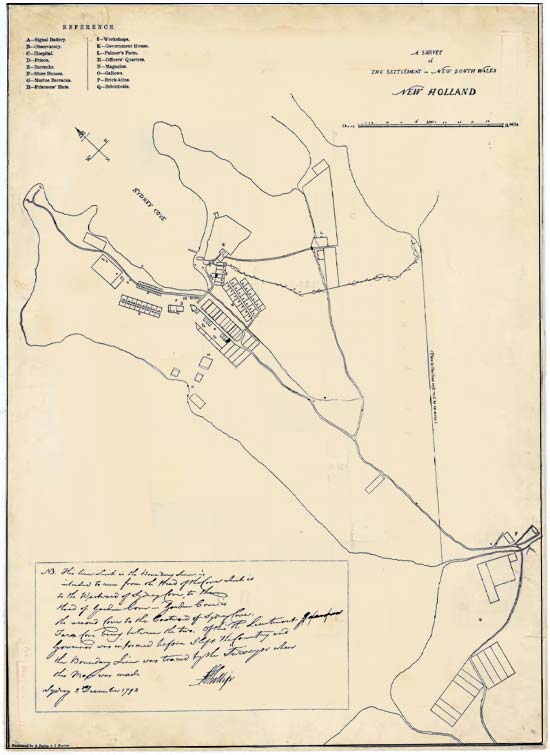
Left: "A Survey of the Settlement" (1792)(Governor Arthur Phillip)(???). This is Phillip's "boundary line" inside which all the land was government land, and NOT to be given in grants to settlers. Typically Australian, future governors and civil servants overlooked this dictat.
Righr: "Plan of the Town and Suburbs of Sydney" (1822)(State Library of NSW). The site of the convict garden is laid out in a grid just off-centre, and numbered "40". To the right is heading east.

We now know this area as Cook+Phillip Park, between St Mary’s Cathedral (foundation stone laid 1821) and the Australian Museum (building work started in 1846) which is bounded primarily by College Street (street constructed in 1832) and William Street (construction commenced in 1836). The veggie garden pre-dates all four of these locators, occupying some of the Sydney Grammar land, most of the Museum land, the start of William Street, and much of the cathedral forecourt. However, it now exists in historic documents only. There is nothing on the ground as evidence that it existed at all.

Left: Photograph of the Gardener's Lodge (1880)(Australian Museum Archives). This is the only knpown photograph. There are artistic interpretations, as I have indicated. The lodge is the octagonal building on the right.
Right: Click on this 2013 photo of the Museum, in an aerial shot from Sydney Tower, I have included a big red X about where the lodge was located. In the 2015 rejuvenation of the Museum entrance, this spot has been overwhelmed by the "floating glass Crystal Hall" which I personally find under-whelming.

There had been physical evidence – once upon a time. The gardens were laid out as one would expect from those accustomed to English gardens: a large square divided by walkways into four (smaller) squares, with a central circle, and in this central circle, stood the gardener’s lodge. The octagonal lodge was located at the NE corner of the first Museum building which was opened in 1857. The lodge was constructed c. 1820 when hopes for the success of the venture were high. It was demolished between 1880 and 1885, in preparation for major remodelling of the two existing Museum buildings, and the construction of the third (southern) wing. It had been occupied by a police constable and his family in the 1840s, and then used by the Museum as a taxidermist’s workshop until c. 1865, when it was converted into a kitchen and wash-house. It was single storey, with a central chimney, made from brick and stucco, with a shingle roof.

Left: Frontispiece to "A History of NSW: From its Settlement to the close of the Year 1844" (1844)(Braim, TH)(Caroline Simpson Library & Research Collection, SLM/HHT). This appears to be a view from College Street, looking north-east over Woolloomooloo Bay. the Potts Point ridge, with Garden Island and Port Jackson.
Right: "Panoramic View of College Street and Hyde Park" (1867-1870) (Johan Nepomuk Degotardi)(State Library - NSW). The western swathe of the Convict Garden is, at least, fenced it, and appears to be hosting a couple of goats.

The convict garden was no more, but the "parkland" remained in government hands, being hived off for a range of uses until 1998. Sydney Grammar was allocated the southern-most portion beside the Francis Forbes allotment. Beside that, land was ear-marked for the Australian Museum, and behind that, one of a number of National Schools. A strip was used to widen the top-half of William Street, some temporarily given to the Blind Institute, some to the Hyde Park Nursery, and some allocated to a lawn-bowling club. Not only did the garden go to rack'n'ruin, but Hyde Park Barracks did not fare much better, until the 1970s, when a new civic awareness, and a respect for our convict heritage blew through the town.


"Looking south-east from the tower atop St James" (1871)(Supplement to Illustrated Sydney News)(State Library - NSW). The cathedral is a burnt shell. The northern side of the Museum is obscured by dense brush. The diagonal walking track through the convict garden is now a road for carts and gigs.

The Barracks Veggie Patch - Part 1
The Barracks Veggie Patch - Part 2 (coming soon)

References

"Lost Convict Lodge Rediscovered"

"The Convict Vegetable Garden that never really was"

Research Skills in Practice (2013) (Matthew Stephens, SLM)(Museum of Sydney)

The Sydney Gazette (8 May 1819)(P1-2)

Heritage Assessment: Cook and Phillip Parks (March 1997)(Lawrence Neild and Partners, Australia Pty Ltd)(Spackman & Moss Pty Ltd)(University of Sydney)

Etheridge, R., 1919. The Australian Museum—fragments of its early history. Records of the Australian Museum 12(12): 339–400, plates xlv–xlix. [4 December 1919]

The Domain: Volume 2 - Cultural Landscape Study (Royal Botanic Garden and Domain Trust)(Rosemary Annabel)

Cook+Phillip Park(City of Sydney)(March 2013)


Wednesday, 29 January 2014

Sydney from on high (6)

I have swung right around nearly to where I started this series 6 days ago. This must be close to due east. There are two city streets intersecting where Hyde Park North meets Hyde Park South. The street with the bus, and the red cars in it, is William Street. At this very intersection the name of the street changes to Park street. If you continue up the street (to the left) you will reach Kings Cross. If you continue down the street (to the bottom of the image) you will reach the Sydney Town Hall. The street that runs across the image is College Street.

There are two major buildings fronting College Street. The one on the corner with William Street is the Australian Museum of Natural History It is the building with the vast expanses of green roof. The building next in is Sydney Grammar School. You can see its quadrangle playground. Here use this magnifying glass. This school is the reason the street is College Street. From 1830 to 1850, the sandstone building fronting the street was Sydney College. That sandstone building is called "Big School". Is is a greater public school, and they are allowed to have boy-jokes like that. In 1852, the building, supported by an act of parliament was reopened as SGS, specifically as a feeder for the newly established University of Sydney, out on Petersham Hill.

From the observation level of the Sydney Tower, Sydney, Australia.

Wednesday, 20 June 2012

William Street: Faces and facades

Being a creature of habit, I wander the alleys and lanes of eastern Sydney, then happenchance has me passing Berkelouw's Book Store on my way home. Resistance is futile, so I find myself lumbering up the stairs to the third floor where all the second-hand books are stashed on shelves, with ladders to assist the vertically challanged.

A quick check: yes, only $17.00 so within my budget. And as I opened it, a cascade of newspaper clippings from 1996 fluttered down. Ooo I love it when someone has cared enough to stash their 'findings' within. I am not far into it yet, but I gather the Royal Commission of 1908 which widened the lower portion of Oxford Street, also proposed the widening of William Street by resuming properties on the southern side. These photographs were taken prior to that work commencing.

All the photographs of people and places in this book were taken between 10th and 19th June, 1916. The location is William Street and its surrounding lanes. The book was published in 1982.
Standing at College Street, lookin up William Street towards Kings Cross. The opposite direction to my lead photograph.

Sunday, 12 February 2012

Chard Stairs


Ever had a memory that flashes in your brain, but you cannot seem to grasp it, to enable closer examination. I have a memory of this 'area'. In 1958, my paternal aunt had a bed-sit in the building on the left. It has been renovated out of recognition, but I have stalked the area, and this is the only candidate. I was 10 and television was oh so new in Sydney. My aunt had her own apartment, and in that apartment was a television. Next to the television was a floor lamp with a scarlet velvet lampshade which cast an eerie red glow. I was very impressed.


Forbes Street runs from Taylor Square in Darlinghurst, across William Street, and into Wooloomooloo where it is stopped by the Plunkett Street housing estate and school. Originally, I guess it to have ended down near the Finger Wharf, about where Harry's Cafe de Wheels stands. It was named in honour of Sir Francis Forbes, the first Chief Justice of the Supreme Court of NSW from 1824 to 1837.

Forbes Street consists of a number of sudden 'dips', and down onto William Street is one of those dips. William Street was widened in 1916 (by demolishing buildings along its south side, the side which now boasts these steps). The steps, built in 1925 totally cut Forbes Street and prohibit vehicular traffic. Mr W.H. Chard was a local land-holder.

Saturday, 11 February 2012

Sunday, 5 February 2012

Greening of William Street

Looking east up William St from Hyde Park, 1890

The replications here are not spot on: mainly because I did not know I was going to treat them as a 'Then & Now'.

Firstly, with the shots I took yesterday, it is obvious that the Lord Mayor's plan to soften William Street is working a treat. There is a way to go before it is a 'boulevard', but I am liking what I see thus far.

As for the 1890 shot, it is from the National Library (oops), so I gather it to be accurate. Hard to believe it is the same street, do you agree? I might wander the street and do a feature on it. Both William and Oxford Streets are in the financial doldrums.

Looking west down William St from the top of the Cross, 2012
Looking east up William Street from Forbes St, 2012
For those who know Sydney, I think the photographer was standing close to the intersection of Park and College Streets, meaning that the forecourt of St Marys has that imposing house, and the tree-lined fence is around the Museum. I am researching for a series. Hang in there.

Sunday, 25 September 2011

William Street Laneway Festival


What do your reckon these two young blokes are doing? Firstly, I thought they were the promised DJs, but they did not have headphones, and that flat white 'board' was not bristling with wires. Now the jeans were hanging from a rope lashed to their upstairs verandah. Could they be designers who are going to decorate the jeans. If you know, tell us. If not, make it up!


Yesterday in Sydney, the sky was a brilliant blue, the temperature was over 30C, and for most of the day a slight breeze fluttered. Today in Sydney, was a dismal grey, the temperature was under 19C, and it drizzled. And today was the second ever William Street Laneway Fashion Festival. Yes, yes - there is an inanity in that title. Let's press on ...


Right now is a tough time for retailers. Consumers are not consuming - well they are consuming, but experiences not possessions. So retailers have to work very hard to get their hand in the consumer-pocket. This is the sort of 'experience' that young folk are craving. But I think the organisers need to do more. They need more music. They need more food, but not in tents, on portable hog-dog stands. They need a coffee cart. They need a distinctive Laneway carry bag. They need more decoration, for the shops to 'spill out' onto the street. To win the hearts and pockets of consumers, they must provide an experience.

Monday, 19 September 2011

Beneath Kings Cross


Once again, I took these shots from the Rushcutters Bay pedestrian overpass.

The road below me is New South Head Road, previously William Street as it wound its way from Hyde Park up to the top of Kings Cross.


The first shot shows a cyclist coming out of the cross-city tunnel heading east. The second shot is a bit more complex. In the very middle is the the on-ramp from Kings Cross if you want to head east. On either side of this on-ramp are the in and out of the the Kings Cross (William Street) tunnel. The 'road' on the far left is the road to the west beneath the entire CBD (cross city tunnel).

The final shot is facing to the east, and shows the Eastern suburbs railway flanked on either side by the short split of New South Head Road. Remember,here in Australia we drive on the left of the road.

Tomorrow, I will show you the Rushcutters Bay pedestrian overpass.

Thursday, 18 August 2011

The spice in variety


Both in William Street, same side of road. Not adjacent, but not far apart at that. Yet so very different style.


There is a French 'feel' to 'I like birds' and its new and vintage homewares. I suspect it will suit me down to the ground, so feel compelled to return and unzip my pockets a bit. The other terrace, which really is ME, is simply labelled McLean and I think to be a private lodging.

Monday, 15 August 2011

Just William


What better to do with your Saturday afternoon, than huddle around a chocolate shop in William Street in Paddington.

'Just William' instantly transports me back to my childhood when maiden aunts gave me books for festive days; books like the Just William series about the English school-boy, William Brown. The first book was published in 1921, being written by Richmal Brown, and illustrated by Thomas Henry. More of a contrast with the Harry Potter series it would be hard to find.


Don't just drool against the glass panes: name your poison. What will you have? Hard centres or soft. Truffles, pralines or ganache. Or maybe you would prefer Turkish Delight, or Rocky Road or chocolate coated licorice. Ah, but how about the 'big daddee' of them all: the Gold Gift box, weighing in at 3.5kgs, containing 225 chockies and making your back pocket lighter to the tune of a mere $500.

Go on! You know you want to.

Today, on A Pied Dans Les Rues de Paris, I feature two Parisian chocolate shops.

Thursday, 2 June 2011

Paddington Posters (1) - Underwood Street


Underwood Street (which is parallel to Oxford Street) crosses William Street a block to the north. It is a narrow jaggy street, but that is not unique in Paddington. On one corner sits a laundromat, and on another a pub, The London.

The laundromat is in a two storey, non-descript terrace building, plentiful in Paddington, which probably dates from the 1880s. Beside the laundromat, is a barely sign-posted graffic design studio.

I gather that commissions are scarce, and income borderline.

Thursday, 5 May 2011

Atop the Cross - William Street


Here we are atop the Kings Cross tunnel looking south at the old fire station. This is the point where Darlinghurst Road and Victoria St cross over (in the form of a x). A whole swag of this land was 'given' to the first NSW Surveyor General, Sir Thomas Mitchell for services rendered. By all accounts a most vengeful and vindictive chap.


Can you just see the fire-station above the tram in the LH image? Both images taken in the late 50s, the second shows the view back up William St from the city proper, about a kilometre. Of course, I am ignoring the elephant in the room: the giant neon Coke sign.


Comparison of two maps: then (1950s)and now. See the tram lines through the centre of William St. Many of those LH buildings down WIlliam Street have been demolished.


View Larger Map

And finally, from beneath the Coke sign, looking west from Kings Cross to the city proper.

Sunday, 19 December 2010

A bold passion


The retail precint of Paddington tends to be other than subtle. It overflows with well credentialled, well paid, well endowed young people who live on the street and play loud music. End of grouch.

Tessarella House offers superb jewellery for the emboldened free spirit. Many of the other stores offer 'frocks' with insufficient material put together in a 'what-the-heck' style with price tags to make one blush.

In its defence, I feel the need to point out that these images were taken on a Wednesday at 7am and the few people on the street were hurrying up to the main drag to catch a bus.